Read Shift Vectors File
This option will read in an FME file of Shift vectors and 'match' them to the points in the job.
The FME file consists of co-ords for the shift point and the reference point,
together, they form a shift vector.
The program matches the points by the Easting/Northing co-ordinate values and the layer.
You will need to have the Shift Points on one layer and the Reference points on another layer.
Display Shift Vectors
Tick this box to show the shift vectors on the main screen as arrowed lines from the Shift Point to the Reference Point
The Shift Vectors can also be turned on/off in the Toolbar 'Display Settings' option.
FME File
Enter the name of the FME shift file.
Click here for details of the FME File Format.
Browse...
Click to browse the disk to select the FME File
Shift Points Layer
Select the Layer containing the Shift POINTS.
Note that the Shift Parcels/lots may be on a different layer to their Points.
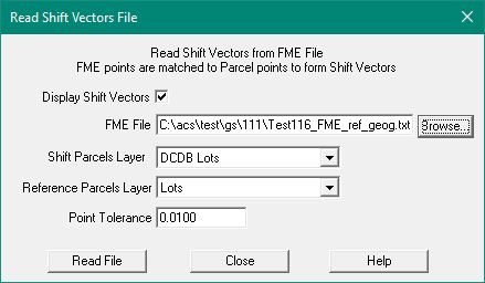
Reference Points Layer
Select the Layer containing the Reference POINTS.
Note that the Reference Parcels/lots may be on a different layer to their Points.
Point Tolerance
Enter the point matching tolerance in metres.
The program will find the Closest point in the job to the co-ordinate read from the file.
It will only match job points on strings on the nominated layer.
Geographics
If the point co-ords read in are with these ranges they are treated as geographic values.
They must be in decimal degrees and will be converted to Easting/Northing for point matching in the job.
- Latitude - from -60 degrees to +60 degrees
- Longitude - from 100 degrees to 160 degrees
The expected geographic file format is FME File Format.
Compute Shift Vectors
Edit Shift Vectors
Shift Vector Settings
Read Shift Vectors file
Write Shift Vectors file
Write Shift Vectors to an FME format file
Write Shift Vectors to an ESRI format file